Enough people have asked how I plan a long ride that I decided to try to capture the magic so to speak. I use a Garmin GPS unit, and plan most of my rides using the Garmin Basecamp software on my Mac. Basecamp is free, powerful and flexible, but even Basecamp has some issues that make me wish for a better alternative.
I am planning a long ride this weekend, so I'll lay out my planning process and show the products along the way. What's a long ride? I can't answer that for you, but for me it is anything over about 500 miles - a full day of relaxed riding. I can manage 750 in a day fairly easily, and 1,000+ miles isn't beyond my reach, but that ceases being fun riding in my opinion. I'll do it for a purpose, but not for entertainment.
This is not a Basecamp tutorial. There are plenty of those on the Google. This is not a safety lecture. Also plenty on the Google. This is a glimpse inside my mind - prepare for chaos!
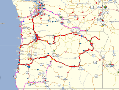
I have 2 priorities this weekend. I want to get a few more Big Money Rally points, and I want to visit all 7 Oregon Tour of Honor sites. Here's my starting point based on the rallies I am playing so far...this is Big Money Rally, Tour of Honor and a few other interesting stops. Different symbols mean different things to me.
 |
| Washington and Oregon Bonus Sites |
Obviously I cannot include every stop, but I know I want to visit all 7 Oregon Tour of Honor sites in this ride (red flags on map), so I will start there.
 |
| Route including all 7 Oregon TOH sites. |
So that's a good start. Now, if I am already down that far south, I might as well go a little farther and grab some Big Money Rally points to get to the next level. Plus, it's a good excuse to continue my ride down the coast. Another consideration this time of year is the condition of mountain passes. I use the state's DOT site to look at cameras and get an idea of what the road looks like. I can also do this while out on the road on a gas stop.
The route I have planned above has some snowy high passes (top picture below), so I look farther south at the lower pass south of Crater Lake (bottom picture below). Here's the difference, and my new route.
And based on this observation, my new route.
Now that I have the basic route mapped out I can start looking at how long each leg should be, where to stop for the night and if I will have any gas station problems. Of note, in Oregon you are not allowed to pump your own gas - although on a motorcycle they are allowed to hand you the nozzle, but they still have to swipe your card and start the pump. Not a huge deal...until it is late and the station isn't open. That's the real drawback to riding in Oregon; the gas station on your map may not be open :(
What do all the symbols mean? I use different colors and shapes to differentiate the bonus types. In this example they are simply different rallies and stops on rallies. On a timed rally I can use the colors and shapes to draw my attention towards more high-value stops and sometimes it helps me visualize an achievable but challenging route.
I can't efficiently access this information on my laptop on the road, so I try to capture the major aspects in a note on my phone. Here's a look at some of the info I put in the note to help me on the road.
Stops are listed in order. I put estimated arrival times so I can keep track of my progress. I have found that if I set my speed preferences correctly in Basecamp and add about 2 or 3 minutes per stop, my arrival time is generally accurate and I get a good idea if I am falling behind or have time to do some extra sightseeing.
The pictures are match examples for a few of the picture match bonuses I am planning to visit. One stop shopping.
Some ride plans are more challenging, and stuff happens out on the road, so I typically plan an "escape route" in my longer days. Usually it means I have a couple of pre-identified stops that I can eliminate to save a lot of miles, or I include a couple of extra possible hotel stops so I don't have to search while in the middle of nowhere.
I usually don't plan in gas stops - I can reliably get 200+ miles between fill ups - but will do a little research for rides in sparsely populated areas to make sure I don't get too far down the road without options.
So that's the plan. Now I just need to ride it.
Updates:
$800 donated to Mission 22
$70 pledged to Operation Tango Mike (and this ride should add another $70 to that total)


No comments:
Post a Comment