Thursday, April 27, 2017

How to Plan a Ride

There are probably as many different approaches to planning out a long ride as there are people planning them. I have personally adapted to what I think is the best answer for me. I suppose I would say I am still not 100% happy since I continue to toy around with new programs and techniques.

Enough people have asked how I plan a long ride that I decided to try to capture the magic so to speak. I use a Garmin GPS unit, and plan most of my rides using the Garmin Basecamp software on my Mac. Basecamp is free, powerful and flexible, but even Basecamp has some issues that make me wish for a better alternative.

I am planning a long ride this weekend, so I'll lay out my planning process and show the products along the way. What's a long ride? I can't answer that for you, but for me it is anything over about 500 miles - a full day of relaxed riding. I can manage 750 in a day fairly easily, and 1,000+ miles isn't beyond my reach, but that ceases being fun riding in my opinion. I'll do it for a purpose, but not for entertainment.

This is not a Basecamp tutorial. There are plenty of those on the Google. This is not a safety lecture. Also plenty on the Google. This is a glimpse inside my mind - prepare for chaos!

I have 2 priorities this weekend. I want to get a few more Big Money Rally points, and I want to visit all 7 Oregon Tour of Honor sites. Here's my starting point based on the rallies I am playing so far...this is Big Money Rally, Tour of Honor and a few other interesting stops. Different symbols mean different things to me.

Washington and Oregon Bonus Sites
Obviously I cannot include every stop, but I know I want to visit all 7 Oregon Tour of Honor sites in this ride (red flags on map), so I will start there.
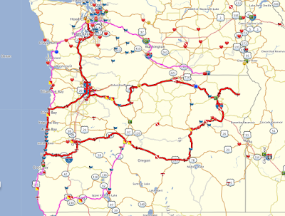
Route including all 7 Oregon TOH sites.
So that's a good start. Now, if I am already down that far south, I might as well go a little farther and grab some Big Money Rally points to get to the next level. Plus, it's a good excuse to continue my ride down the coast. Another consideration this time of year is the condition of mountain passes. I use the state's DOT site to look at cameras and get an idea of what the road looks like. I can also do this while out on the road on a gas stop.

The route I have planned above has some snowy high passes (top picture below), so I look farther south at the lower pass south of Crater Lake (bottom picture below). Here's the difference, and my new route.


And based on this observation, my new route.


Now that I have the basic route mapped out I can start looking at how long each leg should be, where to stop for the night and if I will have any gas station problems. Of note, in Oregon you are not allowed to pump your own gas - although on a motorcycle they are allowed to hand you the nozzle, but they still have to swipe your card and start the pump. Not a huge deal...until it is late and the station isn't open. That's the real drawback to riding in Oregon; the gas station on your map may not be open :(

What do all the symbols mean? I use different colors and shapes to differentiate the bonus types. In this example they are simply different rallies and stops on rallies. On a timed rally I can use the colors and shapes to draw my attention towards more high-value stops and sometimes it helps me visualize an achievable but challenging route.

I can't efficiently access this information on my laptop on the road, so I try to capture the major aspects in a note on my phone. Here's a look at some of the info I put in the note to help me on the road.


Stops are listed in order. I put estimated arrival times so I can keep track of my progress. I have found that if I set my speed preferences correctly in Basecamp and add about 2 or 3 minutes per stop, my arrival time is generally accurate and I get a good idea if I am falling behind or have time to do some extra sightseeing.

The pictures are match examples for a few of the picture match bonuses I am planning to visit. One stop shopping.

Some ride plans are more challenging, and stuff happens out on the road, so I typically plan an "escape route" in my longer days. Usually it means I have a couple of pre-identified stops that I can eliminate to save a lot of miles, or I include a couple of extra possible hotel stops so I don't have to search while in the middle of nowhere.

I usually don't plan in gas stops - I can reliably get 200+ miles between fill ups - but will do a little research for rides in sparsely populated areas to make sure I don't get too far down the road without options.

So that's the plan. Now I just need to ride it.

Updates:
$800 donated to Mission 22
$70 pledged to Operation Tango Mike (and this ride should add another $70 to that total)

Sunday, April 16, 2017

Washington Complete - Weekend Ride


Riding in the Pacific Northwest during the Spring requires patience and the ability to be flexible (and have good rain gear!). You need to be ready to change your plans when a few decent days appear on the forecast. This past weekend provided me an opportunity to ride east and visit the 4 remaining Washington memorial locations.

I am a planner. I try to have a good idea where I am going and how I am going to get there before I ever leave the house. Why? Safety. Having a plan ensures I don't bite off more than I can chew and ride within my limits. It has served me well.

This ride plan involved getting to eastern Washington, but Mother Nature wasn't cooperating and pass travel was going to be iffy on Friday, so I decided to ride south to Portland and then follow the Columbia River Gorge east. It was damp all the way to the Vancouver area, but once I turned east the weather quickly improved and my gear dried out.

First stop - a POW/MIA memorial near Goldendale, WA. Funny story - I had been here before and never noticed this memorial. This location is actually located next to one of my favorite Gorge places - the Stonehenge replica! I guess I was always distracted by the view from the replica site and never turned around. Nice stop.

The POW/MIA memorial near Goldendale, WA.

A closer look. This would be a great place to take a few moments and reflect on the sacrifices of others.

Turned around, looking towards the Columbia River - and there's the Stonehenge replica site.

My next stop for TOH was in the southeast corner of the state near Clarkston. This bridge serves as a memorial to local area people who served in WWI. The 4 pillars of the bridge have a list of names. This part of the ride was a slog along I-84. I finally got off the freeway and followed US-12 though some beautiful areas of Washington from Richland to Clarkston.

Asotin Memorial Bridge.

Each pillar has a similar plaque with names from WWI vets.

Not a huge bridge, but huge meaning.
Asotin was my last stop on Friday evening and I headed up to Lewiston, ID for the night.

Saturday started early. I mentioned planning, and my plan was to get to Snoqualmie Pass (I-90) during the peak afternoon hours to maximize my chances that weather would be cooperative. I didn't want to drive all the way back down to Portland again! Out of the hotel by 4am for a quick breakfast stop before I was headed north for Spokane. I encountered a red turn signal at 4am in sleepy Lewiston, ID. I stopped. I waited for what I thought was a reasonable amount of time and it didn't change. I looked, I went. The deputy didn't agree with my assessment of how long I waited, but did let me go with a warning :)

Spokane was not my next TOH site, but it was a stop on another rally I was riding. My next TOH stop was Tonasket - tucked pretty far north along the east slopes of the Cascade Mountains. What this really means is there is no easy way to the town this time of year since all the passes are still closed by snow, so I kind of looped down and back up to bypass highway 20 over Sherman Pass. Good weather was my riding partner Saturday so the extra miles really didn't matter that much.

Tonasket - a veteran's memorial in a nice setting.


The Armed Forces Legacy Project in Tonasket, WA.

An idea for my lawn - maybe the HOA won't mind?

Honoring veterans, both living and dead.

A wider view of the sections of the memorial.

I am not sure if this is the original location, but it is home now.

Sometimes making a ride enjoyable means stopping for no real good reason other than scenery. This shot was a quick roadside stop on Lake Chelan. I seldom see this lake so calm - usually it is rough from wind or boat traffic. Very quiet today, it will be crazy this summer.

Lake Chelan.

My last stop was an area I have spent a fair amount of time exploring - Cashmere, WA. This was another memorial that I have driven right by without glancing at it. Located in a riverfront park in Cashmere - the same park we have used to pull rafts out of the river with friends Ken and Karlene. I bet I have been within 25 feet several times and never took a moment to visit.

This is a 9/11 memorial site. The sculptures are made to allow someone to stand in and hold hands with the emergency responders. Also included is a piece of steel from one of the towers and a section of the pentagon. This is a relatively small site, but it is truly impressive and well done. I would say this one is one of my favorites so far.

Vistors are encouraged to stand in and hold hands.

Steel from one of the towers, cement from the pentagon.

Dedication for the memorial.

One of the many plaques mounted, and my favorite one.

Now I am done with Washington State. All 7 sites visited, and I was the second rider to do so for this state. I made good on my timeline to arrive at the pass, but the weather was so nice I decided to take a look at the higher (and usually snowier) Stevens Pass. The best way to check on pass conditions in my experience is to go the gas station at the end of town and wait for someone coming down the mountain to pull in. All looked good so up I went, and it was absolutely perfect all the way over the top. Road surfaces dry, no rain and sunny skies. There is still a LOT of snow on the side of the road.

I forgot my chains...

Totals so far:

7 sites visited.

So far my riding has raised $700 for Mission22, and I have committed $70 to Operation Tango Mike.

The Mission22 donations are coming from my GoFundMe page (link at top), and the OTM donations are my plans based on how many sites I visit this year.

Thanks for following along.

Monday, April 10, 2017

TOH Update - 3 Visits


I took advantage of some decent weather this past weekend to go visit the nearby Washington memorial sites on the Tour of Honor. I was getting a little antsy and needed to get at least 1 site under my belt. Low hanging fruit :)

Saturday's adventure was very close (just down the street in Bremerton) and I was able to time a quick trip around the raindrops. The picture of the memorial makes it look like the sun was out, but you don't get to see the dark clouds moving over the area and sprinkling me with rain!

The Bremerton site was the most interesting of the 3 I visited. The centerpiece of the memorial is twisted steel beams from ground zero in NYC. The walking surface around the beams is used to tell the tragic story of the 4 separate impacts (north tower, south tower, pentagon and Pennsylvania field). The wall behind the memorial is faced with tiles decorated by school children with messages of hope and support. The memorial is well done.

The TOH rally requires each submission to include the memorial, my rally flag and my motorcycle. It takes a bit of creativity to figure out how to capture all 3 together. That's why my submission is a little farther away than I could have been if I had just taken a picture of the memorial itself.

Steel beams from Ground Zero (Bremerton)

Dedication plaque (Bremerton)

Messages of hope and support from kids (Bremerton)

My Bremerton submission.
I had planned a longer ride Sunday to visit Oak Harbor (Whidbey Island) and Darrington sites. I combined the ride with some Big Money Rally bonus visits, too, but my focus was TOH this ride. Planning ahead revealed one of the main highways I had planned to use was closed due to a mud slide with no projected opening date. A detour added about 75 miles to my ride, but it wasn't a long ride mileage-wise so I didn't worry about it too much. Oak Harbor is most easily reached by the Port Townsend ferry. A non-eventful ferry crossing had me at the Oak Harbor site by about 9am. This was another site that required me to think about where to put my bike to make sure it was in the picture. That's why it is parked across the street!

The Oak Harbor memorial is dedicated to flight crews that have been stationed at Whidbey Island Naval Air Station over the years, and there are several plaques with names and assignments dating back before the Vietnam War.

My Oak Harbor submission.

Dedication plaque (Oak Harbor)
The ride from Oak Harbor to Darrington is 2 lane state highway all of the way. It was a good day to be out riding since the roads were dry (for once!) and traffic was light (the North Cascades Highway is closed further east until later this Spring so not as much through-traffic). I made good time with a quick stop for gas and a snack and made it to the memorial. It always amazes me how I can travel 50 miles away from Seattle and feel like I am in a different state without crowds and traffic.

This memorial is positioned in a cemetery, and that posed challenges since I didn't want to walk on a grave to get the picture. I want to try to respect the site as much as possible.

While I was taking a break for another quick snack a series of emergency vehicles sped past back in the direction I needed to go. I was a bit nervous since any road problems might strand me out here for hours! No worries, though. Not sure where the emergency was, but it wasn't on my route.

My submission for Darrington.

Dedication plaque for Darrington.

I give the mountains credit for trying to show up...#toomanyclouds

Overall a pretty productive weekend. I have visited a total of 3 memorial sites. My GoFundMe page got off to a strong start, and I have received many messages promising donations later this summer. I am planning my next ride to eastern Washington to complete the state by visiting the remaining 4 memorial sites later this month.

Totals so far:
Memorials - 3
State Finishes - 0 (so far)
Money Raised for Mission22 - $700
Money Committed for Operation Tango Mike - $30 (and counting)

Get out there and make a difference!

Sunday, April 2, 2017

TOH Sites Released, Rally Starts

Link to my GoFundMe page here.

Link to my Spot location while riding here.

Several very generous early donations have my total at $700 as of April 1st! I am very grateful for the support.

The locations for Tour of Honor 2017 were released on April 1st (no April Fool's Joke!) and it is a nice list of riding destinations. Here's a glimpse of what is in store through the end of October for my home state of Washington.

TOH sites for Washington state.
And as luck would have it, one of the locations is just down the street from me. I am sure that will be my first success this year! So what is required of this rally? Ride to the location and take a picture of the memorial with your bike and a rider flag in the picture. The picture has to be a reasonable match to a provided sample image like the one below for the Tonasket, WA location.

Sample image for Tonasket, WA memorial location.
The rally organizer has also provided a bit of history for each location. For Tonasket they said:

"The Armed Forces Legacy Project is an ongoing project designed to build and maintain the legacy of the armed forces and those who have served. Unlike a memorial, the project accepts the names of living veterans as well as deceased. This one half acre project is a staffed organization which will help veterans to understand and apply for their benefits."

If you are interested in seeing your state just comment on this page with the state name and I will post it in my next update, or visit the TOH website and take a look at the interactive map - see it here.

Several great ride ideas are possible in the TOH rally. One that has me intrigued is completing an IBA Saddlesore ride while visiting all 7 locations in a state. I took a look at Washington and could collect all 7 with a 1000+ mile effort (in less than 24 hours). A Saddlesore ride is an IBA sanctioned event in which the rider travels at least 1,000 miles in less than 24 hours. The trick is to find something nearby that produces a dated receipt (like a gas station) for verification purposes.

I have 2 documented Saddlesore rides and several non-documented rides. Here's a route that is probably not the optimal order for my state.

Notional route to collect all 7 Washington memorial sites in one long ride (~1028 miles)


Tell me what you think - leave comment on this blog. I will answer as soon as I can - I approve all comments before publishing to limit spam.

I did manage to get out this weekend to take advantage of our 1 day of summer in the PNW. I hope I am kidding about this, but so far it has been nothing but cold and wet. I could ride, but it wouldn't be enjoyable. My trip this weekend took me in to British Columbia for a bonus on the Big Money Rally at someone's house. It was a lot of fun meeting up with riders that you normally only see through a website. A bit of rain early was chased away by broken sunshine and reasonable temperatures.

That's it for now. I'll post another update after my first memorial visit :)

Getting Ready For Our Canary Island Cruise

  Canary Island Itinerary We are preparing to depart on our long-awaited Canary Island cruise with friends! We fly into Lisbon, Portugal and...